Monday, March 16, 2020

Masada


Masada is an ancient fortification in the southern part of Isreael. It is situated on top of and isolated rock mountain. next to a mesa below. It in on the eastern of the Judean Desert overlooking the Dead Sea, It is 12 miles east of Ariad. Herod the Great had two palaces built for himself up on the mountain. It was around 37 to 31 BC.  The enemies of the Jewish naion claim that they were there first but this time of the Jews was hundreds of years before the enemies even existed.

Records show that the last of the Sicaril Jewish rebels died by suicide, 74 BC rather than be captured by the Roman Armies of ten thousand soldiers.They actually had a system where people were voted to be the ones to take peoples lives while they slept. On person, the last to survive, had to take his own life.


 The path to the top of this settlement was taken as people walked along narrow paths. Some of the original paths can still be taken today. The paths only that were used made the area a very fortied locating from the enemies. 


Today there are two cable cars the can be taken up to the top of the mountain. Many people are crowded onto the cars, standing room only. It is an amazing sight to see as we are taken up to the new elevaton.


When one arrives to the top the first sight shows a very desolate desert area. Lots of sand and rocks with no vegetation.

Some of the buildings have been restored to give the feel of how it flet to live there. My suggestion is that they could have had pole frames and tent like coverings for some of the people to live in in the open areas.
An out of order photo shows  the wooden ramps that we walked to get to the top of the area.


When the Romans tried to get to the top of the mountain they could not. Behind the mountain, they built a ramp from rocks and sand. A large battering tower was built and rolled up to invade from the top of their outer walls. The walls did double duty as walls of houses along the edge of the Masada living area.  Remember at first it was built for the King to live and he died many years before this last settlement was created.


Waiting to go into a room that is a part of the outside wall. A surprise is inside as you enter.


A Jewish man sits inside of one of the rooms along the wall of the fortified mountain. The room is the part of the wall.  A Jewish man sits inside and has a glassed wall between us.  He can hear us as we tell him our names and he writes in script with his ink pen our names on a square of paper.  The slits between the glass lets us drop in a donation and he hands us his art work of a name card.


While they lived on the mountain they had seeds to plant for vegetables.  They made cubicles for pigeons to live in up on the top of the mountains. They must have fed them to keep them there.  Also they used the droppings from the pigeons as fertilizer with their plants. The soil apparently can grow things as long as there is water put on the plants.


Large cisterns were created when the King  Herod lived there and the canals from the mountains above diverted water down into the very large cisterns. The King had been dead alot of years before the time when the   Jewish group was hiding up there.


The sides of the mountain show how hard it was for people to invaded the place.  There were paths that could be fortified to prevent entry.
These structures were build to show how they originally protected themselves from the hot sun. The materials like this were collected and and carried up the mountain.


At one area we could see worship area and you could overlook the whole valley.  One could see all the desert areas, today's planting of crops and the Dead Sea.

While up on the mountain we could hear and see the Israel Air Force flying over the country. They have purchased these from the United States. As small as Israel is in land territory, the planes could protect their land from invasion in an instant. It is an bone chilling experience hearing the sound of this jets, knowing that we assisted them in their purchase, and knowing that they do have a lot of power to protect their land and people.


When the whole area was restored and cleared the archeologist left an area to show what they had found when they first started. If you can see all the rock rubble in the center, back of the photo, that is how the city was found.  Two thousand years of more did make the area shift and fall in the temperature changes of the seasons.


If you can see the squares on the surfaces of the land down below, you can see where the Roman troops had set up during the siege of Masada. The one square is the outline of the small walls they build around there camps.  There were 10,000 Roman soldiers surrounding the whole mountain.  There goal was to take slaves and or kill every Jewish person living on the top of the mountain. Those squares of encampments were scatter all around the mountain.


When it was possible the restorers of the walls would paint a black line to show how high the wall was before they started to pile rocks back up onto them.


I imagine this whole area was planted with some gardens and the rest was posts and roofs for people to live under, like a tent city.


The ramp that was built to the back of the city is shown here.  The carried in soil and stone to create this ramp to the back wall.  They created a wooden structure, like a tower on wheels, to roll up to the outer wall. The structure on wheels didn't work so well but soldiers did succeed to break through in the middle of the night.  When they arrived on top, all the people were dead.  It was said a couple of mothers and children were hovered in a cistern or two.


Masada is not mentioned in the bible.  Its history comes from survivors who share what they knew to an author.  His writings give everyone an idea of what happened on the mountain.  Masada is a testimony of the devotion of the Jews in relationship with God.  They knew that slavery was not a wish for themselves or their children.  They also did not wish to give to the Romans a victory by them slaughtering them because of their religion. To visit the area is a way or going back into time.  The people are gone but the signs of the people are still there.  There are museums that hold a lot of the artifacts of their everyday tools, pottery and weapons. The visit is more than an adventure but a way of visiting history from a very long time ago.

Monday, February 3, 2020

The Sea of Galilee with a Voyage.


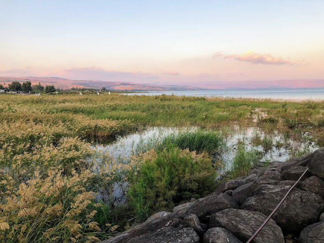
Our first view of the Sea of Galilee, also known as Lake Kinneret. It is in the Galillee province and looks very tropical from this side of the lake. The Bible describes many miracles that happen with Jesus along the whole lake. The main source of water is the Jordan River that is just around the corner of this photo.  Flooding rains recently north of here in December  raised the lake water level by three inches.


As a part of our tour we stopped at St. Pete's Fish Food to eat talapia.  There are always great salad sections to choose from with the Mediterranean flare. 


This plant flourishes along the highways in Israel. They are also growing in some of the National Parks as well as near this restaurant.


The afternoon sun shines on the opposite side of the lake causing the glwing color. Sailboats and other fishing boats are on the lake.


 The swampy look along this area of the lake allows a lot of different wild grasses to grow.


At the south end of the lake we were allowed to take a boat ride across the lake. The sun was going down behind mountains to our west so it did become dark by the time we finished our journey.


An American flag was hoisted for us along with the flag of Israel. It was a larger boat built especially for these tourist cruises.


It was amazing to be able to look out over the water and to be able to watch the waves. This was taken about five minutes as the sun immediately sat in the west.


The land of the west shore of the lake hid the setting sun. Once out on the water it went down pretty fast. You can see the hotel spots along the shore. I didn't realize the moon in the sky until I posted this photo. The one planet that tags along with the moon sometimes was up there on the right of this partial phase. I found it personally amazing to be able to see the same moon that I see at home on the opposite side of the earth.


Once out on the water Jewish songs with dancing took place.  The seating was all around the sides of the boat so this festive dancing could take place.


Elin Gev was across the lake and we did end up sailing beside the shore before we returned to our original dock. It was a wonderful experience of being on the Sea of Galilee. Land that runs a narrow band along the lake is still Israel country.  It is a narrow strip and we did travel along it the next morning.  Syria sits probably twenty miles to the east all along the country in northern Israel.


As we left the shore we walked by a harbor of private boats, off of the Sea of Galilee. The lights and setting sun made it into a wonderful shot.

Wednesday, January 15, 2020

Cesarea Phillipi....and Tel of Dan.


At the time when the land was divided by tribes, this land was given the name of Dan. It is recorded in the book of Judges.  The area was originally held by Canaanites. The people were from Crete. The whole area of Israel is considered the panhandle of Galilee. The earliest of maps of that area shows that the Dan assignment by God extended far above where the present country line. The city of Tyre was in Israel and it is now in Lebanon.


The area has had a Jewish presence for many more years, earlier than the Muslim who claimed that it was their land. Their religion had not been invented yet. There are two large springs that spill out large amounts of water from the surrounding mountains, making the whole area park-like with deciduous trees.


The stone railing is built up to the small river's making it a pleasant place to walk. You can see the cattails growing in the stream along with other water plants. You can hear rapids from different parts of the river.

The streams build up and become the headwaters of the Jordan River.  The river is a major source for water to all of Israel as it travels all the through the Sea of Galilee and beyond.

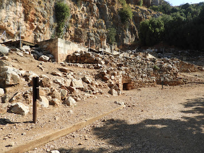
At the side of this park area is Mount Hermon.  It is a range of mountains along the stream. In a area at the base of the mountain near there is a site of a palace in ruin. It has been there for thousands of years. 


At the site of the palace are carvings of niches along with a cave. The niches were created to hold false gods, idols. for people to worship.  The Jewish people were influenced at the time that they lived there.  One of the idols that your are familiar with would be golden calves and wooden Baals.  The Jewish people were familiar with this kind of worship as they saw it being done in Egypt.  So the people in the area who were not Jewish encouraged this type of beliefs and the  Jewish people joined in to the practice.

The practice of idol worship got the Jewish people  throughout Israel into trouble with their God and he allowed the Babylonians drag them off into slavery.The land became vacant and different wandering desert tribes moved in to the  area.

When you first see the carved niches in the mountain you do feel that something special was placed into them. The Jewish people changed their people's fate for quite a few years before they were really able to return in 1949. It was more than 2,000 years.


As we left this area we were bused a few miles south to go on a walking tour up in the hills of Dan. As we meandered through a lot of forest to go the two sites, we crossed bridges that went over the Jordan River.


My point that the springs put out a lot of water is proven here by seen all of the water rushing out of the area.


While on the hill of the Tel of Dan we find this gate.  It was a part of a walled-in area that controlled who was allowed to enter.  The whole piece is so fragile that the canopy was built to protect it from the weather. This whole area was another time period from the many different sets of people who lived in the area. When the   Jewish people first lived here their were Crete people who did not build the different things up on this hill.


I have seen tourist spots on the net showing that the doors do open.  I imagine there is just ruins of walls behind them.


The stairs are really rugged remains of what were probably smooth steps at one time.


Walking further up the hill is another time period where a king of the area, not Jewish, who would sit here at the gate and count his livestock as they passed by him.
In the same area you can see the remaining walls of the walled city area. The stones place on the ground could have been original ones but then they were filled in so the road would be smooth. These rocks were very difficult to walk on. It is interesting to see that the Jordon River is keeping things growing in the area with deciduous trees. Israel is more desert than this so the river really helped make things grow, including grass.


Further up on the hill is another generation of a civilization.  King Herod build a worship center here hoping it would compete with the Temple in Jerusalem.  He didn't want the people in Northern part of the country to travel down to Jerusalem.  The ironic part of this area was that false gods were worshiped here instead of God. The king thought it would maybe dilute down the worship of God for other gods that the  Jewish people saw being worshiped in Egypt.  Three of the last photos were used from a web site called BiblePlaces. com.  It is a good place to visit to see all of Israel.